
|
Last update at: Oct 9, 2024, 03:45 AM
Go to Top
Go to Top
Go to Top
Go to Top
Go to Top
Go to Top
Go to Top
Go to Top
Go to Top
Go to Top
Go to Top
Go to Top
Go to Top
Go to Top
Go to Top
|
Frequently Asked Questions Printer Friendly Version |
|
Closures & Advisories Search Conditions By Map Search By City Search By Route Search By District Variable Speed Limits Chain Law Neighboring States |

| District Comments | |
|---|---|
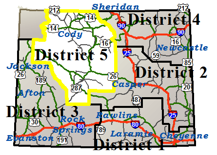
| District 5 (Northwest) | US14A: Water main break repairs, Travel lane blocked near Powell at milepost 24, Proceed with caution. US14: Local and hunter traffic allowed between Greybull and Burgess Junction from milepost 35 to 38.3. |
|
Basin
NWS Forecast Basin |
|||||||
|---|---|---|---|---|---|---|---|
| Route | Location | Conditions | Advisories | Restrictions | Last Report Time | Cameras | Sensors |
| US 14/16/20 | Between the Big Horn County Line and 4 miles west of Greybull | Dry | None | None | Oct 9, 2024, 03:32 AM |

|
|
| Between Greybull and Shell | Dry | None | None | Oct 9, 2024, 03:32 AM | |||
| Between Shell and Antelope Butte Mountain Recreation Area | Dry | Falling Rock | None | Oct 9, 2024, 03:32 AM |
|

|
|
| US 16/20 / WY 789 | Between Greybull and Basin | Dry | None | None | Oct 9, 2024, 03:32 AM |
|
|
| Between Basin and Manderson | Dry | None | None | Oct 9, 2024, 03:32 AM |
|
||
| US 14/16/20/310 / WY 789 | Between Greybull and 4 miles west of Greybull | Dry | None | None | Oct 9, 2024, 03:32 AM |
|
|
|
Cody
NWS Forecast Cody |
|||||||
|---|---|---|---|---|---|---|---|
| Route | Location | Conditions | Advisories | Restrictions | Last Report Time | Cameras | Sensors |
| US 14/16/20 | Between Pahaska and the Shoshone National Forest Boundary | Dry | Falling Rock | None | Oct 9, 2024, 03:32 AM | ||
| Between the Shoshone National Forest Boundary and Cody | Dry | Falling Rock | None | Oct 9, 2024, 03:32 AM |
|
||
| Between Cody and the Big Horn County Line | Dry | None | None | Oct 9, 2024, 03:32 AM |
|
||
| US 14 A | Between Cody and Powell | Dry | None | None | Oct 9, 2024, 03:32 AM |
|
|
| US 212 | Between Mile Marker 4.5, Westbound Closure Gate and WY 296 | Dry | Falling Rock | None | Oct 9, 2024, 03:32 AM | ||
| WY 120 | Between Cody and the Montana State Line | Dry | None | None | Oct 9, 2024, 03:32 AM |
|
|
| WY 296 | Between US 212 and WY 120 | Dry | Falling Rock | None | Oct 9, 2024, 03:32 AM |
|
|
|
Dubois
NWS Forecast Dubois |
|||||||
|---|---|---|---|---|---|---|---|
| Route | Location | Conditions | Advisories | Restrictions | Last Report Time | Cameras | Sensors |
| US 26/287 | Between the E Boundary of Grand Teton Nat'l Park and Lava Mountain Lodge | Dry | None | None | Oct 9, 2024, 03:32 AM |
|
|
| Between Lava Mountain Lodge and Dubois | Dry | None | None | Oct 9, 2024, 03:32 AM |
|
||
| Between Dubois and Diversion Dam Jct | Dry | None | None | Oct 9, 2024, 03:32 AM |
|
||
|
Lander
NWS Forecast Lander |
|||||||
|---|---|---|---|---|---|---|---|
| Route | Location | Conditions | Advisories | Restrictions | Last Report Time | Cameras | Sensors |
| US 287 / WY 789 | Between Sweetwater Station Jct and Jct WY 28 / US 287 | Dry | None | None | Oct 9, 2024, 03:32 AM |
|
|
| Between Jct WY 28 / US 287 and Lander | Dry | None | None | Oct 9, 2024, 03:32 AM |
|
||
| Between Lander and Diversion Dam Jct | Dry | None | None | Oct 9, 2024, 03:32 AM |
|
||
| WY 131 | Between Lander and Sinks Canyon State Park | Dry | None | None | Oct 9, 2024, 03:32 AM | ||
| WY 132 | Between US 287 and Ethete | Dry | None | None | Oct 9, 2024, 03:32 AM | ||
| Between Ethete and US 26 | Dry | None | None | Oct 9, 2024, 03:32 AM |
|
||
| WY 789 | Between Lander and Hudson | Dry | None | None | Oct 9, 2024, 03:32 AM |
|
|
|
Lovell
NWS Forecast Lovell |
|||||||
|---|---|---|---|---|---|---|---|
| Route | Location | Conditions | Advisories | Restrictions | Last Report Time | Cameras | Sensors |
| US 14 A | Between Powell and the West Jct US 310 / WY 789 | Dry | None | None | Oct 9, 2024, 03:32 AM | ||
| Between Lovell and 22 miles east of Lovell | Dry | None | None | Oct 9, 2024, 03:32 AM | |||
| Between 22 miles east of Lovell and the Sheridan/Big Horn County Line | Dry | Falling Rock | None | Oct 9, 2024, 03:32 AM | |||
| US 310 / WY 789 | Between 4 miles west of Greybull and Lovell | Dry | None | None | Oct 9, 2024, 03:32 AM |
|
|
| Between Lovell and the West Jct US 310 / WY 789 | Dry | None | None | Oct 9, 2024, 03:32 AM | |||
| Between US 310 / WY 789 and the Montana State Line | Dry | None |
US 310 / WY 789 at milepost 257.010 Single unit 4-5 axles: 26T , Single unit 6+ axles: 30T |
Oct 9, 2024, 03:32 AM |
|
||
| WY 114 | Between Garland and Deaver | Dry | None | None | Oct 9, 2024, 03:32 AM | ||
|
Meeteetse
NWS Forecast Meeteetse |
|||||||
|---|---|---|---|---|---|---|---|
| Route | Location | Conditions | Advisories | Restrictions | Last Report Time | Cameras | Sensors |
| WY 120 | Between WY 171 and Meeteetse | Dry | None | None | Oct 9, 2024, 03:32 AM |
|
|
| Between Meeteetse and Cody | Dry | None | None | Oct 9, 2024, 03:32 AM |
|
|
|
| WY 431 | Between US 20 / WY 789/432 and WY 120 | Dry | None | None | Oct 9, 2024, 03:32 AM | ||
|
Riverton
NWS Forecast Riverton |
|||||||
|---|---|---|---|---|---|---|---|
| Route | Location | Conditions | Advisories | Restrictions | Last Report Time | Cameras | Sensors |
| US 26 | Between Diversion Dam Jct and Riverton | Dry | None | None | Oct 9, 2024, 03:32 AM |
|
|
| Between Riverton and WY 134 | Dry | None | None | Oct 9, 2024, 03:32 AM |
|
||
| WY 135 | Between WY 789 and WY 139 | Dry | None | None | Oct 9, 2024, 03:32 AM | ||
| Between WY 139 and Sweetwater Station Jct | Dry | None | None | Oct 9, 2024, 03:32 AM |
|
||
| WY 136 | Between WY 135 and Gas Hills | Dry | None | None | Oct 9, 2024, 03:32 AM |
|
|
| WY 789 | Between Hudson and Riverton | Dry | None | None | Oct 9, 2024, 03:32 AM |
|
|
|
Shoshoni
NWS Forecast Shoshoni |
|||||||
|---|---|---|---|---|---|---|---|
| Route | Location | Conditions | Advisories | Restrictions | Last Report Time | Cameras | Sensors |
| US 20 / WY 789 | Between Boysen Dam and Shoshoni | Dry | None | None | Oct 9, 2024, 03:32 AM |
|
|
| Between Shoshoni and Moneta | Dry | None | None | Oct 9, 2024, 03:32 AM |
|
||
| Between Moneta and Waltman | Dry | None | None | Oct 9, 2024, 03:32 AM |
|
|
|
| US 26 / WY 789 | Between WY 134 and Shoshoni | Dry | None | None | Oct 9, 2024, 03:32 AM |
|
|
| WY 133 | Between Kinnear and Pavillion | Dry | None | None | Oct 9, 2024, 03:32 AM |
|
|
| WY 134 | Between US 26 / WY 789 and WY 133 | Dry | None | None | Oct 9, 2024, 03:32 AM | ||
|
South Pass
NWS Forecast South Pass |
|||||||
|---|---|---|---|---|---|---|---|
| Route | Location | Conditions | Advisories | Restrictions | Last Report Time | Cameras | Sensors |
| WY 28 | Between the Fremont/Sublette Cty Line and Mile Marker 47 | Dry | None | None | Oct 9, 2024, 03:32 AM |
|
|
| Between Mile Marker 47 and Mile Marker 63, Westbound Closure Gate | Dry | None | None | Oct 9, 2024, 03:32 AM |
|
|
|
| Between Mile Marker 63, Westbound Closure Gate and US 287 / WY 789 | Dry | None | None | Oct 9, 2024, 03:32 AM |
|
||
|
Ten Sleep
NWS Forecast Ten Sleep |
|||||||
|---|---|---|---|---|---|---|---|
| Route | Location | Conditions | Advisories | Restrictions | Last Report Time | Cameras | Sensors |
| US 16 | Between Worland and Ten Sleep | Dry | None | None | Oct 9, 2024, 03:32 AM |
|
|
| Between Ten Sleep and WY 435 | Dry | None | None | Oct 9, 2024, 03:32 AM | |||
| Between WY 435 and Deer Haven Lodge | Dry | None | None | Oct 9, 2024, 03:32 AM |
|
|
|
|
Thermopolis
NWS Forecast Thermopolis |
|||||||
|---|---|---|---|---|---|---|---|
| Route | Location | Conditions | Advisories | Restrictions | Last Report Time | Cameras | Sensors |
| US 20 / WY 789 | Between Mile Marker 148, Washakie/Hot Springs County Line and Thermopolis | Dry | None | None | Oct 9, 2024, 03:32 AM |
|
|
| Between Thermopolis and Boysen Dam | Dry | Falling Rock |
US 20 BUS , WY 789 from milepost 116.100 to 116.500 Width restriction: 12 ft Height restriction: 15 ft |
Oct 9, 2024, 03:32 AM |
|
||
| WY 120 | Between Thermopolis and WY 171 | Dry | None | None | Oct 9, 2024, 03:32 AM | ||
|
Worland
NWS Forecast Worland |
|||||||
|---|---|---|---|---|---|---|---|
| Route | Location | Conditions | Advisories | Restrictions | Last Report Time | Cameras | Sensors |
| US 16/20 / WY 789 | Between Washakie/Big Horn County Line and Worland | Dry | None | None | Oct 9, 2024, 03:32 AM |
|
|
| Between Worland and Mile Marker 148, Washakie/Hot Springs County Line | Dry | None | None | Oct 9, 2024, 03:32 AM |
|
||
| US 16/20 / WY 789 | Between Washakie/Big Horn County Line and Manderson | Dry | None | None | Oct 9, 2024, 03:32 AM |
|
|
|
NWS Forecast |
|||||||
|---|---|---|---|---|---|---|---|
| Route | Location | Conditions | Advisories | Restrictions | Last Report Time | Cameras | Sensors |
|
NWS Forecast |
|||||||
|---|---|---|---|---|---|---|---|
| Route | Location | Conditions | Advisories | Restrictions | Last Report Time | Cameras | Sensors |
|
NWS Forecast |
|||||||
|---|---|---|---|---|---|---|---|
| Route | Location | Conditions | Advisories | Restrictions | Last Report Time | Cameras | Sensors |
| *Chain Law - Level 1 Definition |
| **Chain Law - Level 2 Definition |
| Other Definitions |
| Impact Levels | Description / Recommended Action |
|---|---|
| Low | Minimal impacts expected, use general caution. |
| Moderate | Some impacts expected, use extra caution. Stay alert for changing road and weather conditions. |
| High | Dangerous impacts expected, use extreme caution, delay travel or consider alternate route. If travel is necessary, slow down and allow extra time. |
| CLOSED | Per W.S. 24-1-109, motorists traveling on a closed road without permission from WYDOT or WHP may be subject to a fine of up to $750 and/or up to 30 days imprisonment. |
| Seasonal / Long-Duration Event | Impact level used to distinguish long-duration events from emergent events. |
|
|
|
| Citizen | Business | Government | Visitor | Contact Us | Copyright © 2024 State of Wyoming | Disclaimer | Privacy Policy | Media |
| Production Laramie v. 1.2.0.1868-20240919 | ||||||||