
|
Last update at: Apr 4, 2025, 10:02 AM
Go to Top
Go to Top
Go to Top
Go to Top
Go to Top
Go to Top
Go to Top
Go to Top
Go to Top
Go to Top
Go to Top
Go to Top
Go to Top
Go to Top
Go to Top
|
Frequently Asked Questions Printer Friendly Version |
|
Closures & Advisories Search Conditions By Map Search By City Search By Route Search By District Variable Speed Limits Chain Law Neighboring States |

| District Comments | |
|---|---|
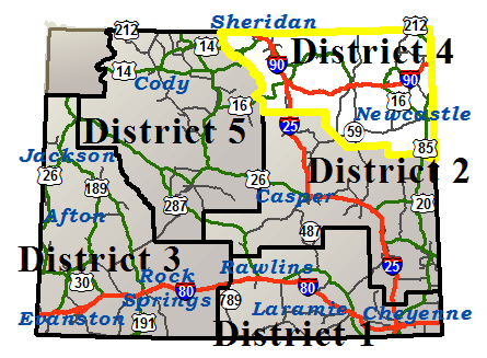
| District 4 (Northeast) | |
| Interstate 25 | |||||||
|---|---|---|---|---|---|---|---|
| Town | Location | Conditions | Advisories | Restrictions | Last Report Time | Cameras | Sensors |
|
Buffalo
NWS Forecast |
Between Exit 265, Reno Rd and Buffalo | Wet, Slick in Spots with Dangerous Winds | Extreme Blow Over Risk |
Closed to all high profile vehicles under 20000 GVW due to extreme blowover risk. All campers under 20,000 LBS are restricted
|
Apr 4, 2025, 10:02 AM |

|

|
| Interstate 90 | |||||||
|---|---|---|---|---|---|---|---|
| Town | Location | Conditions | Advisories | Restrictions | Last Report Time | Cameras | Sensors |
|
Sheridan
NWS Forecast |
Between the Montana State Line and Ranchester | Wet | None | None | Apr 4, 2025, 10:00 AM |
|
|
| Between Ranchester and Sheridan | Wet | None | None | Apr 4, 2025, 10:00 AM |
|
||
| Between Sheridan and Exit 44, Piney Creek Rd | Wet, Slick in Spots, Slush | None | None | Apr 4, 2025, 10:00 AM |
|
|
|
|
Buffalo
NWS Forecast |
Between Exit 44, Piney Creek Rd and Buffalo | Slick in Spots | None | None | Apr 4, 2025, 10:00 AM |
|
|
| Between Buffalo and the Johnson/Campbell County Line | Wet, Slick in Spots, Slush | None | None | Apr 4, 2025, 10:00 AM |
|
|
|
|
Gillette
NWS Forecast |
Between the Johnson/Campbell County Line and Gillette | Wet, Slick in Spots, Slush | None | None | Apr 4, 2025, 10:00 AM |
|
|
| Between Gillette and Rozet | Wet, Slick in Spots, Slush | None | None | Apr 4, 2025, 10:00 AM |
|
||
|
Moorcroft
NWS Forecast |
Between Rozet and Moorcroft | Wet, Slick in Spots | None | None | Apr 4, 2025, 10:00 AM | ||
| Between Moorcroft and Exit 165, Pine Ridge Rd | Slick | None | None | Apr 4, 2025, 10:00 AM | |||
|
Sundance
NWS Forecast |
Between Exit 165, Pine Ridge Rd and Sundance | Wet, Slick in Spots | None | None | Apr 4, 2025, 10:00 AM |
|
|
| EASTBOUND between Sundance and the South Dakota State Line | Wet, Slick in Spots with Blowing Snow | None | None | Apr 4, 2025, 10:00 AM |
|
|
|
| WESTBOUND between Sundance and the South Dakota State Line | Wet, Slick in Spots with Blowing Snow | None |
I 90 , US 14 from milepost 205.700 to 206.100 Height restriction: 15 ft 11 in |
Apr 4, 2025, 10:00 AM |
|
|
|
|
Buffalo
NWS Forecast Buffalo |
|||||||
|---|---|---|---|---|---|---|---|
| Route | Location | Conditions | Advisories | Restrictions | Last Report Time | Cameras | Sensors |
| I 25 / US 87 | Between Exit 265, Reno Rd and Buffalo | Wet, Slick in Spots with Dangerous Winds | Extreme Blow Over Risk |
Closed to all high profile vehicles under 20000 GVW due to extreme blowover risk. All campers under 20,000 LBS are restricted
|
Apr 4, 2025, 10:02 AM |
|
|
| I 90 / US 87 | Between Exit 44, Piney Creek Rd and Buffalo | Slick in Spots | None | None | Apr 4, 2025, 10:00 AM |
|
|
| Between Buffalo and the Johnson/Campbell County Line | Wet, Slick in Spots, Slush | None | None | Apr 4, 2025, 10:00 AM |
|
|
|
| US 14/16 | Between Ucross and Mile Marker 60, the Sheridan/Campbell County Line | Slick | None | None | Apr 4, 2025, 10:00 AM |
|
|
| US 16 | Between Hunter Ranger Station and Buffalo | Slick with Snowfall, Fog | None | None | Apr 4, 2025, 10:00 AM |
|
|
| Between Buffalo and Ucross | Wet, Slick in Spots | None | None | Apr 4, 2025, 10:00 AM | |||
| WY 196 | Between Beaver Creek and Buffalo | Wet, Slick in Spots with Dangerous Winds | Extreme Blow Over Risk | None | Apr 4, 2025, 10:02 AM | ||
|
Burgess Junction
NWS Forecast Burgess Junction |
|||||||
|---|---|---|---|---|---|---|---|
| Route | Location | Conditions | Advisories | Restrictions | Last Report Time | Cameras | Sensors |
| US 14 | Between Antelope Butte Mountain Recreation Area and Elk View | Slick with Snowfall | None | None | Apr 4, 2025, 10:00 AM |
|
|
| Between Elk View and Steamboat Rock | Slick with Snowfall | None | None | Apr 4, 2025, 10:00 AM |
|
||
| Between Steamboat Rock and Dayton School | Wet, Slick in Spots | Falling Rock | None | Apr 4, 2025, 10:00 AM | |||
| US 14 A | Between the Sheridan/Big Horn County Line and Bear Lodge |
Road Closed Due To Seasonal Closure As of April 01 at 08:11 p.m., the estimated opening time is unknown. Parking on the roadway is prohibited and delays WYDOT from opening the road. |
Apr 4, 2025, 10:00 AM | ||||
|
Gillette
NWS Forecast Gillette |
|||||||
|---|---|---|---|---|---|---|---|
| Route | Location | Conditions | Advisories | Restrictions | Last Report Time | Cameras | Sensors |
| I 90 | Between the Johnson/Campbell County Line and Gillette | Wet, Slick in Spots, Slush | None | None | Apr 4, 2025, 10:00 AM |
|
|
| Between Gillette and Rozet | Wet, Slick in Spots, Slush | None | None | Apr 4, 2025, 10:00 AM |
|
||
| US 14/16 | Between Mile Marker 60, the Sheridan/Campbell County Line and WY 59 | Slick in Spots | None | None | Apr 4, 2025, 10:00 AM | ||
| Between WY 59 and Gillette | Slick with Snowfall | None | None | Apr 4, 2025, 10:00 AM | |||
| WY 50 | Between Gillette and Mile Marker 12, Clarkelen Rd Closure Gate | Slick | None | None | Apr 4, 2025, 10:00 AM | ||
| Between Mile Marker 12, Clarkelen Rd Closure Gate and Pine Tree Junction | Slick | None | None | Apr 4, 2025, 10:00 AM |
|
|
|
| WY 51 | Between Gillette and Rozet | Slick with Snowfall | None | None | Apr 4, 2025, 10:00 AM | ||
| WY 59 | Between Mile Marker 94, Haight Rd and Gillette | Slick in Spots | None | None | Apr 4, 2025, 10:00 AM | ||
| Between US 14/16 and Mile Marker 126, Northbound Closure Gate | Slick | None | None | Apr 4, 2025, 10:00 AM | |||
| Between Mile Marker 126, Northbound Closure Gate and the Montana State Line | Slick | None | None | Apr 4, 2025, 10:00 AM | |||
|
Hulett
NWS Forecast Hulett |
|||||||
|---|---|---|---|---|---|---|---|
| Route | Location | Conditions | Advisories | Restrictions | Last Report Time | Cameras | Sensors |
| US 212 | Between the Montana State Line and the South Dakota State Line | Slick | None | None | Apr 4, 2025, 10:00 AM |
|
|
| WY 110 | Between WY 24 and Devils Tower Nat'l Monument | Wet | None |
WY 110 from milepost 0.000 to 0.020 Height restriction: 20 ft 6 in |
Apr 4, 2025, 10:00 AM |
|
|
| WY 112 | Between Hulett and Strawberry Hill | Slick with Snowfall | None | None | Apr 4, 2025, 10:00 AM | ||
| Between Strawberry Hill and the Montana State Line | Slick with Snowfall | None | None | Apr 4, 2025, 10:00 AM | |||
| WY 24 | Between US 14 and Hulett | Wet | None |
WY 24 from milepost 0.000 to 0.100 Height restriction: 19 ft WY 24 from milepost 5.970 to 5.990 Height restriction: 20 ft 6 in |
Apr 4, 2025, 10:00 AM |
|
|
| Between Hulett and the east side of Bear Lodge | Wet, Slick in Spots | None | None | Apr 4, 2025, 10:00 AM | |||
|
Moorcroft
NWS Forecast Moorcroft |
|||||||
|---|---|---|---|---|---|---|---|
| Route | Location | Conditions | Advisories | Restrictions | Last Report Time | Cameras | Sensors |
| I 90 / US 14/16 | Between Rozet and Moorcroft | Wet, Slick in Spots | None | None | Apr 4, 2025, 10:00 AM | ||
| Between Moorcroft and Exit 165, Pine Ridge Rd | Slick | None | None | Apr 4, 2025, 10:00 AM | |||
| US 14 | Between Moorcroft and WY 113 | Slick | None | None | Apr 4, 2025, 10:00 AM | ||
| Between WY 113 and Carlile | Slick | None | None | Apr 4, 2025, 10:00 AM | |||
| US 16 | Between Moorcroft and Weston/Crook County Line | Wet, Slick in Spots | None | None | Apr 4, 2025, 10:00 AM | ||
| Between Weston/Crook County Line and Upton | Wet, Slick in Spots | None | None | Apr 4, 2025, 10:00 AM | |||
| WY 113 | Between US 14 and Pine Haven | Slick | None | None | Apr 4, 2025, 10:00 AM | ||
| WY 51 | Between Rozet and Moorcroft | Slick, Slush | None |
WY 51 at milepost 143.600 Single unit 6+ axles: 33T |
Apr 4, 2025, 10:00 AM | ||
|
Newcastle
NWS Forecast Newcastle |
|||||||
|---|---|---|---|---|---|---|---|
| Route | Location | Conditions | Advisories | Restrictions | Last Report Time | Cameras | Sensors |
| US 16 | Between Upton and Newcastle | Dry | None | Single unit 6+ axles: 32T | Apr 4, 2025, 10:00 AM | ||
| Between Mile Marker 249 and Mile Marker 254, Eastbound Closure Gate | Wet with Snowfall | None | None | Apr 4, 2025, 10:00 AM | |||
| Between Mile Marker 254, Eastbound Closure Gate and the South Dakota State Line | Wet with Snowfall | None | None | Apr 4, 2025, 10:00 AM | |||
| US 16 Bypass | Between Mile Marker 247 and Mile Marker 249 | Wet with Snowfall | None | None | Apr 4, 2025, 10:00 AM | ||
| US 18 | Between Mule Creek Jct and the South Dakota State Line | Wet with Snowfall | None | None | Apr 4, 2025, 10:00 AM |
|
|
| US 85 | Between Mule Creek Jct and Niobrara/Weston County Line | Wet | None | None | Apr 4, 2025, 10:00 AM |
|
|
| Between Newcastle and WY 585, Four Corners | Wet, Slick in Spots | None | None | Apr 4, 2025, 10:00 AM |
|
|
|
| Between Niobrara/Weston County Line and Newcastle | Wet | None | None | Apr 4, 2025, 10:00 AM | |||
| Between WY 585, Four Corners and the South Dakota State Line | Wet, Slick in Spots | None | None | Apr 4, 2025, 10:00 AM |
|
|
|
| WY 116 | Between Upton and WY 450 | Wet, Slick in Spots with Snowfall | None | None | Apr 4, 2025, 10:00 AM | ||
| WY 450 | Between Newcastle and WY 116 | Dry | None | None | Apr 4, 2025, 10:00 AM | ||
| Between WY 116 and the Campbell/Weston County Line | Dry | None | None | Apr 4, 2025, 10:00 AM | |||
|
Powder River Pass
NWS Forecast Powder River Pass |
|||||||
|---|---|---|---|---|---|---|---|
| Route | Location | Conditions | Advisories | Restrictions | Last Report Time | Cameras | Sensors |
| US 16 | Between Deer Haven Lodge and Canyon Creek Rd | Slick with Snowfall, Fog | None | None | Apr 4, 2025, 10:00 AM | ||
| Between Canyon Creek Rd and Sheep Mountain Rd | Slick with Snowfall | None | None | Apr 4, 2025, 10:00 AM |
|
|
|
| Between Sheep Mountain Rd and Hunter Ranger Station | Slick with Snowfall | None | None | Apr 4, 2025, 10:00 AM | |||
|
Reno Junction
NWS Forecast Reno Junction |
|||||||
|---|---|---|---|---|---|---|---|
| Route | Location | Conditions | Advisories | Restrictions | Last Report Time | Cameras | Sensors |
| WY 387 | Between Pine Tree Jct and Wright | Slick in Spots | None | None | Apr 4, 2025, 10:00 AM |
|
|
| Between Wright and Reno Jct | Slick in Spots | None | None | Apr 4, 2025, 10:00 AM | |||
| WY 450 | Between the Campbell/Weston County Line and Mile Marker 54, Eastbound Closure Gate | Slick in Spots | None | None | Apr 4, 2025, 10:00 AM | ||
| Between Mile Marker 54, Eastbound Closure Gate and WY 59 | Slick in Spots | None | None | Apr 4, 2025, 10:00 AM | |||
| WY 59 | Between the Campbell/Converse Cty Line and Mile Marker 67, Edwards Rd | Slick in Spots | None | None | Apr 4, 2025, 10:00 AM | ||
| Between Mile Marker 67, Edwards Rd and Wright | Slick in Spots | None | None | Apr 4, 2025, 10:00 AM | |||
| Between Wright and Mile Marker 94, Haight Rd | Slick in Spots | None | None | Apr 4, 2025, 10:00 AM |
|
|
|
|
Sheridan
NWS Forecast Sheridan |
|||||||
|---|---|---|---|---|---|---|---|
| Route | Location | Conditions | Advisories | Restrictions | Last Report Time | Cameras | Sensors |
| I 90 / US 87 | Between the Montana State Line and Ranchester | Wet | None | None | Apr 4, 2025, 10:00 AM |
|
|
| Between Ranchester and Sheridan | Wet | None | None | Apr 4, 2025, 10:00 AM |
|
||
| Between Sheridan and Exit 44, Piney Creek Rd | Wet, Slick in Spots, Slush | None | None | Apr 4, 2025, 10:00 AM |
|
|
|
| US 14 | Between Dayton and Ranchester | Wet | None | None | Apr 4, 2025, 10:00 AM |
|
|
| Between Sheridan and Ucross | Slick in Spots with Snowfall | None | None | Apr 4, 2025, 10:00 AM |
|
|
|
| US 87 | Between Banner and Sheridan | Slick, Drifted Snow with Snowfall, Blowing Snow, Limited Visibility | None | None | Apr 4, 2025, 10:00 AM | ||
| WY 193 | Between Kearny and Banner | Slick, Drifted Snow with Snowfall, Blowing Snow, Limited Visibility | None | None | Apr 4, 2025, 10:00 AM |
|
|
| WY 194 | Between Story and End of State Route | Wet, Slick in Spots | None | None | Apr 4, 2025, 10:00 AM | ||
| WY 331 | Between Sheridan and Beckton | Slick in Spots, Slush | None | None | Apr 4, 2025, 10:00 AM | ||
| WY 332 | Between Sheridan and WY 334 | Wet | None | None | Apr 4, 2025, 10:00 AM | ||
| WY 335 | Between US 87 and Red Grade Rd | Slick in Spots, Slush | None | None | Apr 4, 2025, 10:00 AM | ||
| WY 336 | Between Sheridan and Dutch Creek Rd | Wet, Slick in Spots | None | None | Apr 4, 2025, 10:00 AM | ||
| WY 338 | Between Sheridan and the Montana State Line | Wet | None | None | Apr 4, 2025, 10:00 AM | ||
| WY 340 | Between Story and North Piney Creek | Wet | None | None | Apr 4, 2025, 10:00 AM | ||
| WY 343 | Between WY 345 and Dayton | Wet | None | None | Apr 4, 2025, 10:00 AM | ||
| WY 345 | Between the Montana State Line and Ranchester | Wet with Snowfall, Fog | None | None | Apr 4, 2025, 10:00 AM | ||
| Between Ranchester and I-90 | Wet | None | None | Apr 4, 2025, 10:00 AM | |||
|
Sundance
NWS Forecast Sundance |
|||||||
|---|---|---|---|---|---|---|---|
| Route | Location | Conditions | Advisories | Restrictions | Last Report Time | Cameras | Sensors |
| I 90 | Between Exit 165, Pine Ridge Rd and Sundance | Wet, Slick in Spots | None | None | Apr 4, 2025, 10:00 AM |
|
|
| between Sundance and the South Dakota State Line | Wet, Slick in Spots with Blowing Snow | None | None | Apr 4, 2025, 10:00 AM |
|
|
|
| between Sundance and the South Dakota State Line | Wet, Slick in Spots with Blowing Snow | None |
I 90 , US 14 from milepost 205.700 to 206.100 Height restriction: 15 ft 11 in |
Apr 4, 2025, 10:00 AM |
|
|
|
| I 90 Business | Between Sundance and South Dakota State Line | Wet, Slick in Spots | None | None | Apr 4, 2025, 10:00 AM | ||
| US 14 | Between Carlile and WY 24 | Slick, Slush | None | None | Apr 4, 2025, 10:00 AM | ||
| Between WY 24 and Sundance | Wet, Slick in Spots, Slush | None |
US 14 from milepost 181.100 to 181.300 Height restriction: 19 ft |
Apr 4, 2025, 10:00 AM |
|
|
|
| WY 111 | Between Aladdin and I-90 | Wet, Slick in Spots | None |
WY 111 from milepost 0.000 to 0.050 Height restriction: 19 ft |
Apr 4, 2025, 10:00 AM | ||
| WY 116 | Between Sundance and Upton | Wet, Slick in Spots | None | None | Apr 4, 2025, 10:00 AM | ||
| WY 24 | Between the east side of Bear Lodge and the South Dakota State Line | Wet, Slick in Spots | None |
WY 24 from milepost 39.650 to 39.670 Height restriction: 19 ft |
Apr 4, 2025, 10:00 AM | ||
| WY 585 | Between Crook/Weston County Line and Sundance | Slick in Spots | None | None | Apr 4, 2025, 10:00 AM | ||
| Between Four Corners and Crook/Weston County Line | Slick in Spots | None | None | Apr 4, 2025, 10:00 AM |
|
|
|
|
NWS Forecast |
|||||||
|---|---|---|---|---|---|---|---|
| Route | Location | Conditions | Advisories | Restrictions | Last Report Time | Cameras | Sensors |
|
NWS Forecast |
|||||||
|---|---|---|---|---|---|---|---|
| Route | Location | Conditions | Advisories | Restrictions | Last Report Time | Cameras | Sensors |
|
NWS Forecast |
|||||||
|---|---|---|---|---|---|---|---|
| Route | Location | Conditions | Advisories | Restrictions | Last Report Time | Cameras | Sensors |
|
NWS Forecast |
|||||||
|---|---|---|---|---|---|---|---|
| Route | Location | Conditions | Advisories | Restrictions | Last Report Time | Cameras | Sensors |
|
NWS Forecast |
|||||||
|---|---|---|---|---|---|---|---|
| Route | Location | Conditions | Advisories | Restrictions | Last Report Time | Cameras | Sensors |
| *Chain Law - Level 1 Definition |
| **Chain Law - Level 2 Definition |
| Other Definitions |
| Impact Levels | Description / Recommended Action |
|---|---|
| Low | Minimal impacts expected, use general caution. |
| Moderate | Some impacts expected, use extra caution. Stay alert for changing road and weather conditions. |
| High | Dangerous impacts expected, use extreme caution, delay travel or consider alternate route. If travel is necessary, slow down and allow extra time. |
| CLOSED | Per W.S. 24-1-109, motorists traveling on a closed road without permission from WYDOT or WHP may be subject to a fine of up to $750 and/or up to 30 days imprisonment. |
| Seasonal / Long-Duration Event | Impact level used to distinguish long-duration events from emergent events. |
|
|
|
| Citizen | Business | Government | Visitor | Contact Us | Copyright © 2024 State of Wyoming | Disclaimer | Privacy Policy | Media |
| Production Laramie v. 1.2.0.1938-20241011 | ||||||||